There is a moment on the Ransi to Madmaheshwar trek that every trekker remembers for the rest of their life.
You have been walking for two days. Your legs are tired. The forest has been dense and beautiful but relentless. And then — somewhere around the 8th kilometer on Day 2 — the trees suddenly stop. The world opens up. And in front of you is a wide green meadow, ancient temple bells ringing softly in the distance, and four of the most magnificent Himalayan peaks you have ever seen, all at once.
That moment is why people come to Ransi. That moment is why they come back.
This is the most complete and honest guide to the Ransi to Madmaheshwar trek available for 2026. Every distance is accurate. Every detail is real. Nothing is copied from a brochure.
Let us begin.
What is the Ransi to Madmaheshwar Trek?

The Ransi to Madmaheshwar trek is the main trekking route to reach the sacred Madmaheshwar temple — the second temple in the Panch Kedar pilgrimage circuit dedicated to Lord Shiva in the Garhwal Himalaya region of Uttarakhand.
Ransi village is the last motorable point on the road from Ukhimath. From here, all further travel to the temple is done entirely on foot. The trek covers approximately 24 km one way through dense Himalayan forests, river crossings, small mountain villages, and finally the magnificent high-altitude meadows known as Madmaheshwar bugyal.
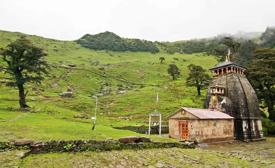
The Madmaheshwar temple at the end of this trail sits at 3,497 meters above sea level — surrounded by views of Kedarnath peak, Chaukhamba, Neelkanth, and Meru — making it one of the most visually spectacular pilgrimage destinations in all of India.
Ransi Village — Your Trek Starting Point
Before the trek begins, let us understand Ransi village properly because most guides skip this completely.
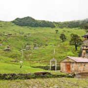
Ransi is a small Garhwali village located approximately 35 km from Ukhimath on a winding mountain road. It sits at an altitude of approximately 1,980 meters above sea level and is the official base camp for the Madmaheshwar trek.
What you will find at Ransi: Basic homestays and small guesthouses, a few tea stalls and small dhabas serving simple food, a small market where you can buy last-minute supplies, mule and porter hiring facilities, and most importantly — the Kedarnath Wildlife Sanctuary forest department check post where every trekker must register before starting the trek.
Registration at Ransi is mandatory. Carry your original Aadhaar card or any government-issued photo ID. Without registration you cannot proceed on the trail. The process is quick, free, and takes about 5 minutes. Do not skip it.
From Ukhimath to Ransi: Shared jeeps and private taxis are available from Ukhimath early morning. The road is narrow, steep, and rough in sections but the mountain views throughout the drive are spectacular. Budget 1.5 to 2 hours for this road journey.
Ransi to Madmaheshwar Trek — Complete Route Breakdown
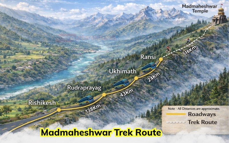
The Ransi to Madmaheshwar trek route is covered over two main trekking days with an overnight halt at Bantoli. Here is the complete stage by stage breakdown:
Stage 1 — Ransi to Gangi Village (3 km)
Distance: 3 km Altitude: 1,980 m to 2,100 m Time: 1 to 1.5 hours Difficulty: Easy
The trek begins at the Ransi forest check post. After registration you walk through the stone-paved lanes of Ransi village itself, passing terraced fields, traditional Garhwali stone houses, and small temples dedicated to local deities.
The first 3 km to Gangi village is the easiest section of the entire trek. The trail is relatively flat with gentle inclines, wide enough for two people to walk side by side, and offers beautiful views of the valley below and the distant forest above.
Gangi village is a small settlement with a tea stall and a few houses. Most trekkers stop here for their first chai break of the day. The local families here are warm and welcoming — if you have time, a quick conversation with a local about the trail ahead is always worthwhile.
Stage 2 — Gangi Village to Bantoli (10 km)
Distance: 10 km Altitude: 2,100 m to 2,250 m Time: 4 to 5 hours Difficulty: Moderate
This is the longest section of Day 1 and the most physically demanding part of the Ransi to Bantoli trek. After Gangi, the trail enters the dense forest zone of the Kedarnath Wildlife Sanctuary and the character of the trek changes completely.
The path narrows. The tree cover becomes thick with oak, rhododendron, maple, and pine. The sound of the Madmaheshwar river rushing through the valley below becomes your constant companion. In spring the rhododendron trees bloom in deep red and bright pink — the entire forest looks like it has been decorated.
This section has several small but beautiful stream crossings — clean, cold mountain water that you can drink directly. Many trekkers fill their bottles here and the water is genuinely some of the freshest you will ever taste.
The forest section also passes through areas where wildlife sightings are possible. The Himalayan monal — the stunning iridescent pheasant that is the state bird of Uttarakhand — is sometimes spotted in the forest understory in the early morning. Barking deer and langurs are also commonly seen on this section.
The trail gains altitude gradually through the forest before the final 2 km involves a steeper climb up through a narrow forested ridge. And then Bantoli appears — a small clearing in the forest with stone houses, smoke rising from cooking fires, and the unmistakable smell of dal and rice.
Bantoli sits at approximately 2,250 meters and is your overnight halt for Day 1.
Stage 3 — Bantoli to Nanu Village (5 km)
Distance: 5 km Altitude: 2,250 m to 2,800 m Time: 2.5 to 3 hours Difficulty: Moderate to Challenging
Day 2 begins with the steepest climbing of the entire Madmaheshwar trekking route. From Bantoli the trail continues through forest but the gradient increases significantly. You are now gaining serious altitude.
The trail crosses the Madmaheshwar river twice on wooden bridges in this section. The river here is narrower, faster, and louder than below — the sound of it echoing through the forest valley is one of the most powerful sensory memories trekkers take home from this route.
Nanu village is a tiny settlement at approximately 2,800 meters. It has one or two basic tea stalls where you can rest and refuel before the final push to the temple. From Nanu, the forest begins to thin out and the first hints of open sky appear through the tree canopy above.
This section is where altitude begins to be felt by some trekkers. Walk slowly. Drink water consistently. Take breaks when needed. There is no shame in a slow pace — the trail rewards patience far more than speed.
Stage 4 — Nanu Village to Madmaheshwar Temple (6 km)

Distance: 6 km Altitude: 2,800 m to 3,497 m Time: 2 to 2.5 hours Difficulty: Moderate
This is the most magical section of the entire Ransi to Madmaheshwar trek route. From Nanu the trail continues climbing and the forest gradually opens up. The trees get shorter. The sky gets bigger. The air gets crisper and colder.
And then — at approximately the 4 km mark from Nanu — the treeline ends completely.
You step out of the forest and into the Madmaheshwar bugyal. A wide open alpine meadow stretching in every direction. The silence is extraordinary. The air smells of grass and snow and something you cannot quite name.
And the mountains — Kedarnath peak, Chaukhamba, Neelkanth, Meru, and Trishul — are all there, right in front of you, impossibly large and impossibly beautiful.
The Madmaheshwar temple sits in the middle of this meadow at 3,497 meters. Ancient stone walls, wooden carvings, the sound of bells, and the smell of incense drifting out across the meadow.
Most trekkers stand at the edge of the bugyal for several minutes before walking toward the temple. Just taking it in. This is the moment the entire two-day trek was building toward.
Ransi to Madmaheshwar Trek Distance Summary
| Stage | Route | Distance | Time |
|---|---|---|---|
| Stage 1 | Ransi to Gangi | 3 km | 1 to 1.5 hrs |
| Stage 2 | Gangi to Bantoli | 10 km | 4 to 5 hrs |
| Stage 3 | Bantoli to Nanu | 5 km | 2.5 to 3 hrs |
| Stage 4 | Nanu to Temple | 6 km | 2 to 2.5 hrs |
| Total | Ransi to Temple | 24 km | 9 to 12 hrs |
Altitude Profile — Ransi to Madmaheshwar
| Location | Altitude |
|---|---|
| Ransi Village | 1,980 m |
| Gangi Village | 2,100 m |
| Bantoli | 2,250 m |
| Nanu Village | 2,800 m |
| Madmaheshwar Temple | 3,497 m |
| Budha Madmaheshwar | ~3,700 m |
Total elevation gain from Ransi to temple: 1,517 meters
Ransi to Madmaheshwar Trek Difficulty

The Ransi to Madmaheshwar trek difficulty is rated moderate — but here is the honest breakdown:
What makes it manageable: No technical climbing required. No ropes, harnesses, or special equipment needed. Trail is well-marked throughout. Local guides and porters available at Ransi. Maximum altitude of 3,497 meters is high but not extreme for a healthy adult.
What makes it genuinely challenging: Total one-way distance of 24 km is long. No paved sections anywhere — entirely natural mountain trail. No ponies or palanquins available unlike Kedarnath. The Bantoli to Nanu section on Day 2 involves steep and sustained climbing. Nights at Bantoli and near the temple can be very cold even in summer.
Fitness requirement: Start a simple daily walking routine of 5 to 6 km at least 3 to 4 weeks before your trek. Add stair climbing to specifically prepare your legs for the uphill sections. Anyone with basic fitness and genuine motivation can complete this trek successfully.
Where to Stay on Ransi to Madmaheshwar Route
Ransi Village: Small homestays and basic guesthouses run by local Garhwali families. Simple, clean, and affordable at ₹300 to ₹600 per night. Home-cooked Garhwali food available. This is also where most trekkers spend the night before starting the trek.
Bantoli: Forest rest house bookable through the forest department office in Ukhimath. Local homestays also available during peak season. Basic but warm and comfortable enough for one night.
Near Madmaheshwar Temple: GMVN guest house, temple dharamshalas, and a few basic camps near the bugyal. Book GMVN in advance during May-June peak season. Carry your own sleeping bag for extra warmth as temperatures at 3,497 meters drop sharply after sunset.
Best Time for Ransi to Madmaheshwar Trek 2026
May to June 2026: The Madmaheshwar temple opening date 2026 is expected around 21st May. Spring season brings fresh green meadows, rhododendron blooms on the Ransi to Bantoli forest section, pleasant daytime temperatures, and the spiritual energy of the newly opened yatra season.
September to mid-October 2026: Post-monsoon is personally the finest time for this trek. Crystal clear skies after the rains, the sharpest and most vivid mountain views of the year, firm and clean trails, and noticeably fewer crowds than summer. The Madmaheshwar bugyal in October has a golden quality of light in the late afternoon that is unlike anything else in the Himalayas.
Avoid July and August: Heavy monsoon rainfall makes the Ransi to Bantoli trail slippery and the stream crossings potentially dangerous. Landslides are common on the Ukhimath to Ransi road during peak monsoon.
Temple Closing Date 2026: Expected around 20th November after Diwali.
Essential Travel Tips for Ransi to Madmaheshwar Trek
Start early every day: Leave Ransi by 6 AM on Day 1 and leave Bantoli by 6 AM on Day 2. Early starts mean cooler temperatures for climbing, better wildlife sighting chances in the forest, and guaranteed arrival before the afternoon cloud buildup.
Hire a local guide from Ransi: The trail is well-marked but a local guide from Ransi village adds immense value — knowledge of trail conditions, weather patterns, stream crossing points, and genuine safety support in case of emergencies. Guide charges are very reasonable at ₹800 to ₹1,500 per day.
Cash is essential: The last reliable ATM is in Ukhimath. There are no ATMs or digital payment facilities anywhere on the Madmaheshwar trek route beyond this point. Carry enough cash for guides, porters, food, accommodation, and emergencies.
Download offline maps: Mobile network is available at Ransi and Ukhimath but drops significantly beyond Gangi village. Download offline maps on Google Maps or Maps.me before leaving Ukhimath.
Pack a trekking pole: The descent from Madmaheshwar temple back to Ransi is hard on the knees especially after two days of uphill climbing. A trekking pole makes the return journey significantly more comfortable and safe.
Respect the sanctuary rules: The entire Ransi to Madmaheshwar trek route passes through the Kedarnath Wildlife Sanctuary. Do not litter. Do not play loud music. Do not disturb wildlife. Carry all your non-biodegradable waste back out with you.
Final Thought
The Ransi to Madmaheshwar trek is 24 km of forest, river, meadow, and mountain that ends at one of the most sacred and beautiful places in the entire Himalayan range.
It is not the easiest trek in Uttarakhand. It is not the most famous. It does not have helicopter services or paved stone paths or rows of food stalls.
What it has is something far more valuable in 2026 — authenticity.
The silence on this trail is real. The forest is real. The mountains are real. And the feeling you carry home from the Madmaheshwar bugyal — that specific combination of physical exhaustion, spiritual peace, and raw Himalayan beauty — is something no more accessible destination can give you.
Go to Ransi. Start walking. The mountain will do the rest.
👉 Want a completely hassle-free Madmaheshwar trek experience in 2026? Check our Madmaheshwar Tour Package — transport from Delhi, stay at Ransi and near the temple, experienced local trek captain, all meals included, and 24/7 support throughout. Starting at ₹7,000 per person. 10,000+ happy trekkers. Rated 4.9/5.
FAQs
Q. How many km is the Ransi to Madmaheshwar trek? A. The Ransi to Madmaheshwar trek is approximately 24 km one way. The trek is covered in two days — Day 1 covers 13 km from Ransi to Bantoli passing through Gangi village, and Day 2 covers 11 km from Bantoli to the Madmaheshwar temple passing through Nanu village and the Madmaheshwar bugyal. The total round trip distance from Ransi and back is approximately 48 km.
Q. How many days does the Ransi to Madmaheshwar trek take? A. The complete Ransi to Madmaheshwar trek takes 4 to 5 days in total. This includes one day travel from Rishikesh to Ukhimath and then to Ransi, Day 1 trek from Ransi to Bantoli, Day 2 trek from Bantoli to the Madmaheshwar temple, one day at the temple for darshan and Budha Madmaheshwar visit, and the return journey back to Ransi over two days. Budget at least 5 full days for a comfortable and unhurried experience.
Q. Is the Ransi to Madmaheshwar trek safe for solo trekkers? A. Yes, the Ransi to Madmaheshwar trek is generally safe for solo trekkers as the trail is well-marked and local communities along the route are very welcoming. However solo trekkers must register at the forest check post in Ransi, carry a fully charged phone with offline maps downloaded, inform someone about their daily itinerary, hire a local guide from Ransi for extra safety, and carry enough cash as no ATMs exist beyond Ukhimath. Avoid solo trekking during monsoon season or bad weather conditions.
Q. What is the best time to do the Ransi to Madmaheshwar trek in 2026? A. The best time for the Ransi to Madmaheshwar trek in 2026 is May to June and September to mid-October. The Madmaheshwar temple opening date in 2026 is expected around 21st May. May and June offer fresh green trails and rhododendron blooms while September and October give the clearest mountain views and most comfortable trekking conditions after the monsoon. Avoid July and August due to heavy monsoon rainfall, slippery trails, and landslide risk on the Ukhimath to Ransi road.
Q. Where can I hire a local guide or porter for the Ransi to Madmaheshwar trek? A. Local guides and porters are available at Ransi village itself — right at the forest department check post where you register before the trek. You can speak to local families or the check post staff who will connect you with experienced guides from the area. Guide charges typically range from ₹800 to ₹1,500 per day and porter charges are similar depending on the load. Hiring a local guide is strongly recommended for first time trekkers as they know the trail, weather patterns, and stream crossing points in detail.
Q. What should I carry for the Ransi to Madmaheshwar trek? A. For the Ransi to Madmaheshwar trek you should carry warm fleece jacket and heavy down jacket for cold nights, waterproof rain jacket, thermal innerwear, high ankle trekking shoes with good grip, trekking pole for the steep sections and descent, personal water bottle and purification tablets, high energy snacks like dry fruits and nuts, basic first aid kit and altitude sickness medicine, sunscreen SPF 50 and UV protection sunglasses, power bank as electricity is unreliable beyond Ransi, offline maps downloaded before leaving Ukhimath, original photo ID for forest check post registration, and enough cash withdrawn from Ukhimath ATM as no digital payments work on the trail.